
As heatwaves battered countries across the world this summer, the urgency to act on climate change is clearer than ever before. The reduction of CO2 emissions forms the core of necessary action but the mitigation of methane emissions is an important parallel endeavor.
Methane is a much stronger greenhouse gas than CO2 per emitted molecule and as it gets broken down in the atmosphere in about a decade, it also presents a lever to mitigate climate change on a shorter timescale than CO2. Human-made emission sources of methane include livestock, oil and gas systems, coal mining, and waste management. The latter is related to the decay of organic matter in the absence of oxygen, as happens in landfills that harbor organic material such as food waste. Acting on these emissions has recently moved into the global spotlight, with new partnerships and initiatives introduced at the past few climate (COP) conferences. At this year’s COP in Turkey, mitigating emissions from organic waste will again be a key topic. Landfills with organic waste will always emit methane, but how much exactly depends on the waste content and management practices. The more we understand these emissions, the better we can act on them. However, as methane is an odorless and invisible gas, specialized and scarcely available equipment is necessary to measure the gas’ concentrations and estimate emissions. Observations from space can overcome this barrier.
Over the last ten years, there has been a revolution in satellite observations of methane. Satellites can measure the amount of methane in the atmosphere by observing sunlight reflected back from the Earth. That light has passed through the Earth’s atmosphere, where methane molecules absorb light at specific wavelengths (colors). By seeing how much light has been taken away at these wavelengths, we can estimate how much methane is present in the atmosphere. There are now satellites that perform these measurements with a resolution of about 25 by 25 meters on the ground. Using these high-resolution observations, we can detect individual emission plumes of methane (“clouds” of methane that occur downwind of strong emitters) all around the world, including from landfills. Additionally, there are instruments that have coarser but very precise observations over larger areas, enabling the evaluation of urban-level emissions.
The image below shows examples of methane plumes detected using the high-resolution GHGSat satellite instrument at waste sites around the world. One can see methane being emitted at the waste disposal areas and following the wind away from the sites. By combining the methane measurements with wind speed, we can also estimate the emission rates that can explain the detected methane plumes. In a Nature publication from last year, we showed satellite-based emission estimates of over 150 waste sites around the world. As more satellite instruments capable of making these measurements become available, we get more and better observations of an expanding set of sites around the world.
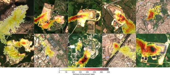
Methane plumes detected at ten sites around the world using GHGSat. The darker the 25 x 25 m squares, the more methane is observed in the detected methane plumes (shown in parts per billion), which can be seen following the wind away from the sites and are shown over visual satellite imagery.
In the ‘Targeting Waste emissions Observed from Space’ (TWOS) project funded by the Global Methane Hub, SRON works together with GHGSat to use satellite observations to support emission mitigation efforts in the Global South. We have developed several applications for the data:
- Prioritize sites. The data can be used to survey a large number of sites to see where there are large methane emissions, these sites can then be prioritized for action.
- Baseline and track emissions. Existing emission rate estimates based on emission modeling can come with significant uncertainty, for example because detailed data on the deposited waste or practices is missing. Satellite data can provide insights into emission rates through the quantification of the detected plumes. These observations can then be used to guide improvements in emission modelling, which is necessary to predict and understand the impact of interventions. Subsequently, the observations can be used to track and demonstrate emission reductions.
- Pinpointing emissions. Because of their high spatial resolution, the satellite data can be used to determine where within a site emissions are originating. We often find that most emissions originate from the ‘active surface’ or ‘working face’ where new waste is added to the site, but have also identified plumes from adjacent biogas infrastructure.
Most importantly, the measurements and insights are shared with local partners. We take recurring (for some key sites, even monthly) observations of specific sites and discuss these observations with our partners to provide insights on the site’s emissions and help us understand how to best use the observations to support their mitigation efforts. Through TWOS, we also support the Lowering Organic Waste Methane (LOW-Methane) initiative hosted by the CCAC. In collaboration with CAREC, TWOS has worked on a survey of methane emissions from prominent landfills in Kyrgyzstan and Tajikistan. Sites with detected emissions are observed multiple times to establish reliable mean detected emission rates. Through collaborations like these, we hope that our satellite data analysis can support the vital reduction of solid waste methane emissions.
Author: Bram (JD) Maasakkers (SRON Space Research Organization Netherlands), on behalf of the TWOS project funded by the Global Methane Hub.
The views expressed are those of the author and do not necessarily reflect the official positions of CAREC or the Global Methane Hub.
Implemented by the Regional Environmental Centre for Central Asia (CAREC) with financial support from Global Methane Hub (GMH), the “WasteMAP: Empowering Methane Action in Central Asia's Waste Sector” project focuses on strengthening national systems for monitoring and managing methane emissions in the solid waste sector through innovative digital solutions. The project will provide access to satellite data and the global WasteMAP platform.
WasteMAP is an online platform developed jointly by RMI (Rocky Mountain Institute) and CATF (the Clean Air Task Force), with support from the Global Methane Hub, aimed at ensuring transparency, measurability, and manageability of methane emissions in the waste sector.